The Loop cuts through ancient market towns, a UNESCO World Heritage Site and Britain's first National Park.
Whether on foot or cycle, for work or recreation, this will be a journey through the history, culture, countryside and communities of Derbyshire. Offering an outstanding visitor experience where you can really feel alive and return home refreshed, inspired and with memories to treasure for a lifetime.
Route information
The route is now open, follow the blue White Peak Loop (WPL) signs and download the GPX file.
The route is 42-miles long with over 2,000ft climb: 5 miles on-road, 37 miles off-road (1 mile of which is 'hike-a-bike'). It follows a variety of surfaces including some sections of public open roads, aggregate tracks, bridleways and traffic-free trails.
If riding 42 hilly miles off-road in a day is no problem, you could complete the route in a day.
If you'd rather ride around 21 miles a day, and have more time to stop off and look at all the interesting things along the way, then you'll want a leisurely 2 days staying overnight at a range of cycle-friendly accommodation.
Plan your adventure
You can find out about suggested multi-day itineraries and plan your adventure at Visit Peak District, you can also view the White Peak Loop film for inspiration.
Future plans
Improvements will be ongoing to meet the high standards and connectivity we aim for. Work continues to make the trail accessible to more people and to progress local connections as part of Derbyshire's ambitious plans for cycling and walking.
We've been awarded a grant from government agency Active Travel England which is an exciting step forward towards extending the route in the future. This funding is being used to progress surveys and preliminary engineering design - including connecting the White Peak Loop from the end of the Monsal Trail at Blackwell Mill to Buxton town centre and train station.
This builds upon previous route appraisals which identified a preferred route from the end of the Monsal Trail along Wye Dale and Woo Dale to Buxton that would involve new bridges over the river. The options involve work within a flood plain, Site of Special Scientific Interest (SSSI) and a Special Area of Conservation (SAC) and will require approvals and further work to fully cost the scheme.
A feasibility study has been completed for the off-road route sections along the Derwent Valley corridor between High Peak Junction and Matlock. Further work is underway to assess the options. It may take some time to complete due to securing the necessary finance, landowner, and other permissions.
Walk the route
This undulating route provides a wonderful trip for long distance walkers too.
As it's not fully waymarked you may need to use a GPS or Ordnance Survey map to join up the Loop from Cromford Mills to Matlock where it follows the Derwent Valley Heritage Way.
You can download the GPX file and view a suggested short break itinerary on the Visit Peak District website.
Horse riding along the route
Horse riders are welcome on the High Peak, Tissington and Monsal shared use trails which form part of the loop.
The Pennine Bridleway National Trailwhich runs for 205 miles through the dramatic Pennine hills from Derbyshire to Cumbria opens up opportunities for the more adventurous.
A start point for this, which is recommended for horse riders is at Hartington Station on the Tissington Trail. A horse box park with turning area has been provided here, along with tethering and watering facilities.
Horse riders may be interested in the South Peak Loop which covers 70 miles of the southern part of the Peak District National Park.
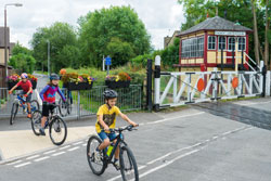
Families
Doing the White Peak Loop with kids is an amazing adventure and experience for the whole family. The Peak District offers so much variety, there is something for everyone.
With kids it can take a little longer so it's best to choose an itinerary that has a few key stops each day with plenty of time for other fun experiences.
Look out for the sculpted benches along the trails and the mural at Friden brickworks.
Take an audio tour at High Peak Junction Visitor Centre workshops. Explore the National Stone Centre next to the High Peak Trail at Wirksworth and the nearby Steeple Grange Light Railway.
Visit the World Heritage Site including Arkwright's Mill (the world's first cotton-spinning mill) near Cromford Wharf.
Use the network to visit the historic towns and villages of Ashbourne, Cromford, Hartington, Tissington and Wirksworth.
Wheelchair users and mobility scooters
The Monsal Trail provides a firm, level surface from the car park at Bakewell Station south to Coombs Road viaduct and north to Blackwell Mill near Buxton (approximately 8.5 miles). Also suitable are sections of the High Peak and Tissington Trails.
All terrain mobility scooters can be hired from:
Accessing the route
There are several car parks along the route which are shown on the Cycle Derbyshire map. However, why not ditch the car and travel by rail or bus?
The route is accessible by train from the local rail stations of Cromford, Matlock Bath, Matlock and Buxton. Spaces are limited to 2 bikes per train. The train companies operate a first come, first served system so it's a good idea to get to the station early so you can make sure you get a space on board the train.
If you're on foot, there are local bus services within easy reach of the route.
The Traveline journey plannerwill help you find the best routes and connections for your journey by bus and train.
More information
We'll add news on future developments for various sections of the route here when known.
For further information, email sustainable.travel@derbyshire.gov.uk